NASA satellite photos taken on March 1st, 2010 reveal that the oil slick from the Deepwater Horizon oil spill show that the Gulf oil spill size has now grown to be larger than Florida.
Original NASA Satellite Photo of Gulf oil slick taken May 1st, 2010.
Credit http://NASA.GOV Download the original satellite image and Google Earth KML file used to create the overlay at http://rapidfire.sci.gsfc.nasa.gov/subsets/?subset=AERONET_WaveCIS_Site_CSI_6.2010121.terra.1km.
Clicking on the KML file from the NASA site launches Google Earth and overlays the photos from the NASA satellite as shown below. It is immediately apparent that the Gulf oil spill size is much larger than projected and way beyond that of official government reports or any news that the main stream media is reporting.

Screen shot of overlay of NASA satellite image taken May 1st, 2010 in Google Earth with edge of oil slick outlined.
After taking a screen shoot of the Google Earth screen I outlined the area of the Gulf oil spill size and then filled the outlined area using Paint.Net.

Overlay of NASA satellite photo of Gulf oil slick taken May 1st, 2010 against full US Map in Google Earth. Here the area of the oil slick has been colored in to show the size.

Close-up Overlay of latest NASA satellite photo from May 1st, 2010 in shows Gulf oil spill size is now larger than Florida.
UPDATE: MUST SEE NEW SATELLITE PHOTOS – SPILL 2X SIZE OF FLORIDA
Update: The Government is definitely holding out.
The Huffington Post took these nice screen shots for us from ABC news.

ABC News is the first main stream news organization showing a more accurate display of the true size of the oil spill matching the overlay above. Notice that bottom half of the spill. which is clearly in the NASA satellite photos is not in the ABC simulation.
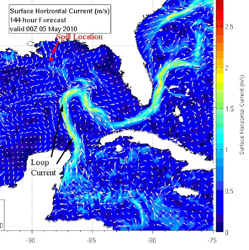
Within hours of this post several oceanographer’s have stepped forward and admit that as the satellite images show, the Gulf Oil Spill is now in the Gulf Loop current, which has prompted the HUGE warning on the Huffington Post that the Gulf oil spill will hit Gulf Loop Current and then Florida Keys in 24 hours and hence the Gulf Stream.
Why are they hiding the truth?
This is the information age the entire world has access to satellite images. For example, from yahoo news:
Mississippi state officials said Monday that the oil had advanced 20 miles closer to the coast since Sunday. However, they said Coast Guard officials assured them that they’d get at least 72 hours notice before the oil threatens the coastline.
And whatever happened to the lowball 1,000 barrel per day estimate? Luckily SkyTruth debunked that and the government quickly revised their numbers to 5,000 barrels per day and made several marine scientists come forward with estimates of 25,000 barrels plus per day.
University of Miami oceanographer Nick Shay tells us that the oil spill has already entered the Loop Current. The loop current pushes into the Gulf in a clockwise swirl, spilling into the Straits of Florida through the Keys and then back north in the Gulf Stream up the Atlantic coast.
Robert Weisberg , an oceanographer at the University of South Florida, says the bulk of the spill is now only 30 miles north of the Loop current and estimates that the oil spill will hit North Caroline in as little as two weeks.
This is truly a global catastrophe. Just consider the thermal image below of the Gulf Stream, whose path the Gulf Oil Spill will follow once hitting the Gulf Stream.

Now consider how these currents interact with other major North Atlantic Currents.
The Global model below shows the relationships between the major Atlantic Ocean currents and the Gulf of Mexico. Meanwhile the US Government refuses give forecast more than three days out and declines to speculate on the potential devastation of the Oil Spill if it makes it way up the US East Coast.

Global Map of Interaction Gulf Stream with Major North Atlantic Currents.
David Mosley, a spokesman from the U.S. Coast Guard at the spill’s command center in Robert, Louisiana told WYFF News 4’s Kim Quintero over the phone Friday afternoon that they can only forecast three days worth of data on wind speeds, direction and sea currents: the driving force of the oil. It would take longer than that for the oil to potentially reach Carolina shores.
This is frustrating – Leaking memo’s showing the government hiding actual data, refusing to inform the public on specifics, turning a blind eye while BP hires fisherman to help clean up the mess while forcing them to sign a waiver that limits them to only $5,000 in liabilities. What is going on here? Senators downplaying the spill as chocolate milk and saying we should not be concerned that this is not Armageddon. Politicians telling us over and over that BP will be responsible for all costs but federal law limits their liability to only $75,000,000 while project cleanup costs are over $5 billion not including additional liabilities.
On CNN today they said they have a way to close the well but BP won’t do it because they would lose the well permanently. Well who cares? Just drill a new one. Our politicians need to stand up and take action.
—- !!!! Update !!!!! —-
That is equal to one Exxon-Valdez oil spill leaking into the Gulf of Mexico every 4 days.