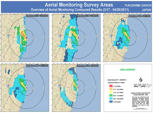
The latest joint US and Japan survey shows extremely high levels of nuclear radioactive contamination, with radiation levels higher than Chernobyl evacuation limits, now span over 800 kilometers in Japan.
Meanwhile US Media outlets continue to ignore the situation and run stories that the situation is under control.
Asashi News Reports:
Radiation-contaminated area spans 800 square km, new map shows
By Hisae Sato and Fumikazu Asai
12 May 2011The total area contaminated with radiation from the Fukushima No. 1 nuclear power plant is estimated at about 800 square kilometers, or about 40 percent the size of Tokyo, according to a radiation map created by the science ministry and U.S. Department of Energy.
The report uses the same level of contamination (555,000 becquerels or higher of cesium-137) that was used to issue compulsory evacuation orders in the Chernobyl nuclear accident in 1986. …
The report’s radiation levels were determined in April by measuring, from about 150-700 meters above ground, levels of accumulated radiation on the ground. The areas measured were divided into 1- to 2-square-kilometer zones.
According to the map, about 800 square kilometers are contaminated with accumulated cesium-137 of 600,000 becquerels or higher per square meter. The substance has a half-life of about 30 years.
[…]
Source Asahi
The article above references data take from the a joint aerial survey conducted by Japan and the US Department of Energy. Here are the maps from the report.
Joint US/Japan Survey — Ground Level C-134 and C-137 Deposition Survey
Joint US/Japan Survey — Ground Level Radiation Dose Rate Survey
Joint US/Japan Joint Survey – Total Radioactive Cesium Deposition Survey
Latest Aerial Survey Shows High Level Radiation Contamination Spans Over 800 Square KM in Japan
A video showing how the aerial survey was conducted.
Late afternoon on Monday, March 14, 2011, the Department of Energy and the National Nuclear Security Administration deployed 33 people and more than 17,200 pounds of equipment – including Consequence Management Response Teams and NNSA Aerial Measuring Systems – to Japan in response to the recent earthquake and tsunami.
This video illustrates how the team managing the Aerial Measuring Systems accomplish their mission. It comes from a training mission in Nevada — it is not footage from Japan.
And more on the current situation in Japan from the Department of Energy Blog.
The Situation in Japan (Updated 05/13/11)
As the situation in Japan continues to evolve, we want to keep you abreast of the latest information on the assistance and expertise we’re providing to the Japanese response and recovery efforts. Please take note of the dates attached to each piece of information, as this is a very fluid situation that is continually evolving.
May 13, 2011
In March, the U.S. Department of Energy released data recorded from its Aerial Measuring System as well as ground detectors deployed along with its Consequence Management Response Teams. Today, the Department provided the following update on the information gathered by the AMS. This is the second round of data that was collected and analyzed jointly with the Government of Japan’s Ministry of Education, Culture, Sports, Science and Technology (MEXT). For a link to the joint monitoring data posted on May 6, visit the MEXT webpage.
Radiation Monitoring Data from Fukushima Area 05/13/2011
File footage of the Aerial Measuring System
Download the SlidesPrevious radiation monitoring data updates:
May 6, 2011 – View the data (Download)
April 22, 2011 – View the data (Download)
April 18, 2011 – View the data (Download)
April 7, 2011 – View the data (Download)
April 4, 2011 – View the data (Download)
March 29, 2011 – View the data (Download)
March 25, 2011 – View the data (Download)
March 22, 2011 – View the data (Download)
Source Department Of Energy (Blog)
See Also:
- Japan Confirms Nuclear Meltdown
- ALERT: Emergency Levels Of Japan Nuclear Radiation Found In Forecasts Censored From Public
- Japan: Compared To Radiation Dumped Into Pacific Ocean Today’s Release Of Half Billion Becquerels Is Nothing
- Reactor 4 Leaning And In Danger Of Complete Collapse
- Extremely Radioactive Sewage Engulfs Over 65 KM Radius From Fukushima Nuclear Plant
- Mislabeled XENON Forecast Map Shows Massive Nuclear Radiation Fallout Cloud Over US
- BAD NEWS — Massive Nuclear Fallout Cloud Of Highly Radioactive Iodine Hammers Japan
- MSM Fails To Cover 700 mSv Radiation Spike Following Massive Fukushima Fire
- Fukushima Japan Groundwater Radiation Contamination Worst in Nuclear History
- Massive Fire Breaks Out At Fukushima Daiichi Nuclear Power Plant May 8th 2011
- Nuclear Expert: EPA Abandoning Radiation Monitoring To Ensure There Are No Measurements Above Levels Of Concern
- TEPCO: Pacific Ocean Radiation Found At Levels Up To 1,000 Normal In Seawater Up To 100 Feet Deep.
- Scientist: Radiation In US Food Will Be Nationwide Problem, Not Just Regional, From Fukushima Nuclear Radioactive Fallout
- Senior Japan Nuclear Scientist Says Fukushima Reactors 1, 2 And 3 All Had Complete Meltdown


