From The Energy Report:
And just when things were looking up for the Gulf. . .a huge underwater oil plume has been discovered.
The hydrocarbon plume/river is 22 miles long, 1.2 miles wide and 650 feet high. It isn’t pure crude, of course; it’s more like a mix of oil and water.
Why isn’t the oil floating to the top? Crude is lighter than water, so it usually does. . .But this spill is different. Apparently, the cold water and high pressure that exist at these depths are preventing it from coming to the surface. Dispersants may be playing a role, as well.
Here’s a graphic of the plume, put together by the Woods Hole Oceanographic Institute (WHOI):
 Sentry, instrumented with a TETHYS mass spectrometer. The vehicle made numerous criss-cross penetrations to map the parameters of the 1,100-meter-deep plume. Woods Hole Oceanographic Institution (WHOI) scientists, who conducted the NSF-funded work in June 2010, report the plume they measured was 1.2 miles wide and 650 feet high. WHOI developed and operates Sentry.")
This illustration shows a plume of hydrocarbons emanating from the Deepwater Horizon oil spill. The plume was identified using the autonomous underwater vehicle (AUV) Sentry, instrumented with a TETHYS mass spectrometer. The vehicle made numerous criss-cross penetrations to map the parameters of the 1,100-meter-deep plume. Woods Hole Oceanographic Institution (WHOI) scientists, who conducted the NSF-funded work in June 2010, report the plume they measured was 1.2 miles wide and 650 feet high. WHOI developed and operates Sentry.
People are calling it a plume, but it looks more like a river to me.
The river of hydrocarbons is currently headed southwest, towards Mexico’s coastline. That could cause a nasty international incident in a few months…
Fortunately, scientists say the plume’s concentrations of toxic chemicals are dispersing as they travel.
But we’re talking about benzene, mercury, and other really nasty chemicals. The full impact of these deepwater plumes is not yet understood.
Scientists from WHOI, along with the Coast Guard and other institutions, used an array of high-tech gadgets — including an autonomous unmanned vehicle (AUV) named the Sentry—along with mass spectrometers, to find and track the plume.
Dr. Richard Camilli of WHOI had this to say: “We’ve shown conclusively not only that a plume exists, but also defined its origin and near-field structure.”
That certainly runs counter to most of the reports we’ve seen so far.
Dr. Samantha Joye, a marine science professor at the University of Georgia, told The New York Times: “The idea that 75% of the oil is gone and is of no further concern to the environment is just incorrect.”
For now, we don’t know if more plumes are lurking out there. The ocean currents at these depths are still somewhat of a mystery, even to scientists who study them for a living.
We can only hope for the best, and be glad that efforts to limit damage from the spill have picked up in recent months.
Just today I talked to a friend who is down in New Orleans, coordinating and working on the cleanup. He told me things have improved dramatically from the chaotic early days.
Thousands of bright folks are working around the clock to clean this one up.
Until next time,
Adam Sharp
Analyst, Wealth Daily
 Sentry, instrumented with a TETHYS mass spectrometer. The vehicle made numerous criss-cross penetrations to map the parameters of the 1,100-meter-deep plume. Woods Hole Oceanographic Institution (WHOI) scientists, who conducted the NSF-funded work in June 2010, report the plume they measured was 1.2 miles wide and 650 feet high. WHOI developed and operates Sentry.")
The original WHOI Press Release adds:
Scientists at the Woods Hole Oceanographic Institution (WHOI) detected and characterized a plume of hydrocarbons that is at least 22 miles long and more than 3,000 feet below the surface of the Gulf of Mexico, a residue of the BP Deepwater Horizon oil spill. The work presents a forensic snapshot of the plume characteristics in June and is reported in a study appearing in the Aug. 19 issue of the journal Science.
The researchers measured distinguishing petroleum hydrocarbons in the plume and, using them as an investigative tool, determined that the source of the plume could not have been natural oil seeps but had to have come from the blown out well.
Moreover, they reported that deep-sea microbes were degrading the plume relatively slowly, and that it was possible that the 1.2-mile-wide, 650-foot-high plume had and will persist for some time.
The WHOI team based its findings on some 57,000 discrete chemical analyses measured in real time during a June 19-28 scientific cruise aboard the R/V Endeavor, which is owned by the National Science Foundation (NSF) and operated by the University of Rhode Island. They accomplished their feat using two highly advanced technologies: the autonomous underwater vehicle (AUV) Sentry and a type of underwater mass spectrometer known as TETHYS (Tethered Yearlong Spectrometer).
“We’ve shown conclusively not only that a plume exists, but also defined its origin and near-field structure,” said Richard Camilli of WHOI’s Applied Ocean Physics and Engineering Department, chief scientist of the cruise and lead author of the paper. “Until now, these have been treated as a theoretical matter in the literature.
…
“In June, we observed the plume migrating slowly [at about 0.17 miles per hour] southwest of the source of the blowout,” said Camilli. The researchers began tracking it about three miles from the well head and out to about 22 miles (35 kilometers) until the approach of Hurricane Alex forced them away from the study area.
Woods Hole has now provided proof that the oil in the massive underwater river is not from natural seeps and has definitively proved the oil from the BP reservoir.
Now let’s recall that Matt Simmons said that BP’s blowout caused a leak 5 to 7 miles away.
A recently released report from the Thomas Jefferson, a ship that has been mapping oil and gas beneath the surface of the sea near the leaking oil, shows just how much worse the BP well blow out could be.
The report of the data collected by the Thomas Jefferson from June 3rd to June 11th revealed a series of oil and and or natural gas leaks have been found coming from the sea floor near the leaking BP Gulf Oil Spill well.
As Matt Simmons stated the ship logs reveal that the Thomas Jefferson located was denied permission to investigate near the well, first being denied permission to get closer than 5 nautical miles and finally being granted permission to come within 3 nautical miles.
From the same report recall that NOAA denied the the leaks coming from the Biloxi Dome 5 to 7 miles away were connected to the BP Gulf Oil Spill and instead dismissed them as pre-existing natural seeps.
3D Model Of Leaks On Gulf Of Mexico Seafloor Near BP Oil Leak Compiled From Data Collected By The Thomas Jefferson
 mapped by Thomas Jefferson, and by Gordon Gunter (purple cylinders) along with CTD stations showing high fluorescence or possible oil and gas anomalies (brown, green and white spheres). The Deepwater Horizon well site is in background (red cylinder) and distribution of Bottom Following Reflectors is represented by orange lines.")
Oil and or natural gas leaks (red and yellow columns) mapped by Thomas Jefferson, and by Gordon Gunter (purple cylinders) along with CTD stations showing high fluorescence or possible oil and gas anomalies (brown, green and white spheres). The Deepwater Horizon well site is in background (red cylinder) and distribution of Bottom Following Reflectors is represented by orange lines.
NOAA has said that the leaks on the sea floor graphed in the 3D model above “appear to be pre-existing seeps that occur naturally and are unrelated to the spill” and have labeled leaks as such in the Thomas Jefferson report.
But how NOAA came to determination the determination that these leaks on the sea floor are natural seeps needs to be questioned.
 mapped by Thomas Jefferson, and by Gordon Gunter (purple cylinders) along with CTD stations showing high fluorescence or possible oil and gas anomalies (brown, green and white spheres). The Deepwater Horizon well site is in background (red cylinder) and distribution of Bottom Following Reflectors is represented by orange lines.")
Today Washington’s Blog posted a great interview Dr. Robert Bea, a scientist on federal government’s flow rate team and one of the world’s leading world’s leading experts in offshore drilling disasters.
Dr. Bea confirmed that BP has in fact drilled into a salt formation during the drilling of the well and during the drilling of the well the sea floor has been become so fractured that oil and methane could continue to leak for years even after sealing it with the relief well.
Top Oil Expert: Geology is “Fractured”, Relief Wells May Fail and Oil May Leak for Years … BP is Using a “Cloak of Silence”
Few people in the world know more about oil drilling disasters than Dr. Robert Bea.
Bea teaches engineering at the University of California Berkeley, and has 55 years of experience in engineering and management of design, construction, maintenance, operation, and decommissioning of engineered systems including offshore platforms, pipelines and floating facilities. Bea has worked for many years in governmental and quasi-governmental roles, and has been a high-level governmental adviser concerning disasters. He worked for 16 years as a top mechanical engineer and manager for Shell Oil, and has worked with Bechtel and the Army Corps of Engineers. One of the world’s top experts in offshore drilling problems, Bea is a member of the Deepwater Horizon Study Group.
…
WB: Might there be problems with the relief wells? I know that it took a couple of relief wells to finally stop the Ixtoc leak, and it has taken as many as 5 relief wells to stop some blowouts.
Bea: Yes, it could take repeated attempts.
WB: Are there any conditions at BP’s well which might make killing the leak with relief wells more difficult than with the average deepwater oil spill?
Bea: That’s an interesting question. You have to ask why did this location blow out when nearby wells drilled in even deeper water didn’t blow out.
You have to look at the geology of the Macondo well. It is in a subsalt location, in a Sigsbee salt formation. [For background, see this and this]
The geology is fractured.
Usually, the deeper you drill, the more pressure it takes to fracture rock. This is called the “fracture gradient“.
But when BP was drilling this well, the fracture gradient reversed. Indeed, BP lost all pressure as it drilled into the formation.
WB: Is it possible that this fractured, subsea salt geology will make it difficult to permanently kill the oil leak using relief wells?
Bea: Yes, it could. The Santa Barbara channel seeps are still leaking, decades after the oil well was supposedly capped. This well could keep leaking for years.
Scripps mapped out seafloor seeps in the area of the well prior to the blowout. Some of the natural seeps penetrate 10,000 to 15,000 feet beneath the seafloor. The oil will follow lines of weakness in the geology. The leak can travel several horizontal miles from the location of the leak.
[In other words, the geology beneath the seafloor is so fractured, with soft and unstable salt formations, that we may never be able to fully kill the well even with relief wells. Instead, the loss of containment of the oil reservoir caused by the drilling accident could cause oil to leak out through seeps for years to come. See this and this for further background].
WB: I know that you’ve previously said that you’re concerned that there might be damage to the well bore, which could make it more difficult for the relief wells to succeed.
Bea: Yes, that’s still a concern.
…
Dr. Bea also informs us that the geology is so fractured that hydrocarbons could leak from fractures several miles away creating the appearance of new natural seeps or even magnifying existing seeps and making them worse.
…
GeoHazard expert BK Lim warned that if BP had in fact drilled near a salt dome a worse case scenario could be playing out.
We now that we have confirmation from Dr. Bea that BP drilled directly into a salt dome and fractured the geology beneath the well you can review the following progression of images showing exactly what happened during the drilling process.
…

Diagram of hydrocarbons from BP Gulf Oil Spill Well leaking through fractured seafloor geology cracked by drilling into a Sigsbee salt formation.

Using those images and the locations of the plumes in those maps I was able to pin down the location of the sea floor leaks from the original NOAA study.

Mapping Of BP Gulf Oil Spill Sea Floor Leaks In Google Earth
I was then able to overlay that map and create a working 3D model of the leaks from the cracks on the sea floor in Google Earth.
After creating the overlay I then added markers to each of the leaks to get the exact location of each seep and then created a KML file for use in Google Earth.

3D map showing the location of the BP and the Rigel Well along with all sea floor leaks that where detected before BP shut in the well.
From that KML file I through together the coordinates for each of the previously confirmed sea floor leaks, the Texaco Rigel Well, and the location of each from the BP well.
…
Here is an updated 3D map showing the location of the BP and the Rigel Well along with all sea floor leaks that where detected before BP shut in the well.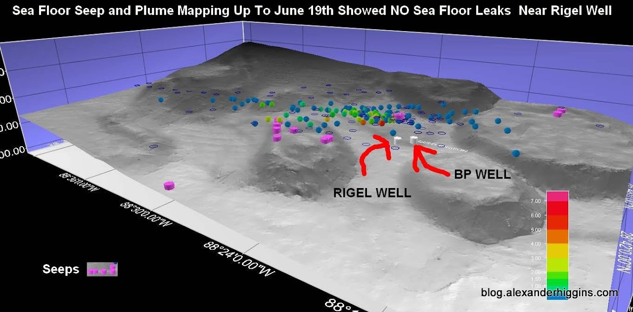
WHOI Confirms Underwater River Of Oil 22 miles Long Originating From The BILOXI DOME 5 – 7 miles southwest of BP Well. WHOI has also confirmed the hydrocarbons are not from natural seeps and are in fact from the BP Well.
…


So Let’s Review
- NOAA says the leaks coming from the sea floor 5-7 miles southwest of BP Gulf Oil Spill Well appear to be natural.
- A top scientist working for the Federal Government says BP fractured the geology around the well so bad it could be leaking miles away.
- WHOI finds a 22 mile underwater river of oil and during their research notice the hydrocarbon anomalies start at 3 miles from the well which is right near the edge of the Biloxi dome.
- WHOI tracks the anomalies across the Biloxi dome and on the other side of the Biloxi dome the hydrocarbons into an underwater river oil that is 1.2-miles wide, 650-foot-high and at least 22 miles long.
- WHOI confirms that the oil in the underwater river is not from natural seeps and proves that the hydrocarbons are from the BP resevior.
Notice that in the 3D model of the river of oil created by WHOI the river starts on the opposite of the Biloxi Dome from the BP Well, past the leaks coming out of the Biloxi dome.
That means the source of the river begins right on top of the leaks coming out of the Biloxi dome.
Now let’s look look at the 3D model of the 22 mile river of oil and put all of this information into a geographical perspective.
Here it is all in one image…
The 22 Mile River Containing Oil From the BP Well Originates At The BILOXI DOME 5 to 7 MILES Southwest of the BP well.

22 Mile Underwater River Of Oil Originating From Biloxi Dome 5 – 7 Miles Southwest Of BP Gulf Oil Spill Well
Here is a recap incorporated into the original WHOI 3D Model of the underwater river of oil.
The Original WHOI 3D Model Of The River Of Oil With Sea Floor Leaks Coming From The Biloxi Dome Included.

22 Mile Underwater River Of Oil Originating From Biloxi Dome 5-7 Miles Southwest Of BP Gulf Oil Spill Well
And to add more fuel to the river of fire…
Here are those four images all together.

Government scientists confirmed that BP has drilled two wells. Is BP Showing the Wrong Well?
…
So here is the latest going around the internet.
I haven’t vetted it yet so watch and make your own judgment.
If the font is to small watch in full screen.
